Importing Preexisting Terrain into SketchUp (and Geolocate a Model)将预先存在的地形导入SketchUp(并对模型进行地理定位)
Does the terrain that you want to model exist somewhere outside your imagination and in digital form? Hurrah! You can just import it!你想建模的地形是否存在于你想象之外的某个地方,并且是以数字形式存在的?万岁!你可以直接导入它!
Well, sort of. Also, after you import terrain, you usually need to edit it. At minimum, you likely need to clean up the imported data by reducing the number of faces to improve your model's performance, tracing contour lines, or a few other tasks covered in Editing and Fine-Tuning Terrain. But for now, enough of the sour details.嗯,差不多吧。此外,导入地形后,通常需要对其进行编辑。至少,您可能需要通过减少面数来清理导入的数据,以提高模型的性能,跟踪轮廓线,或执行编辑和微调地形中涵盖的其他一些任务。但就目前而言,这些令人不快的细节已经够多了。
This section focuses on the happy, easy part of importing terrain. In SketchUp, you can bring terrain into your model in the following ways:本节重点介绍导入地形的快乐、简单的部分。在SketchUp中,您可以通过以下方式将地形引入模型:
Grab a location from Trimble.从Trimble获取位置。In SketchUp Pro, this method is the easiest way to import terrain, and the steps to do it appear later in this section. Importing terrian is not available with SketchUp Make or my.SketchUp.在SketchUp Pro中,此方法是导入地形的最简单方法,其步骤将在本节稍后介绍。SketchUp Make或mySketchUp不支持导入terrian。Import contour lines.导入轮廓线。If your contour lines are a raster image file, you can trace the contour lines in SketchUp. If you can import actual geometry, you just need to turn the contour lines into a TIN (triangulated irregular network) using the From Contours tool, as explained in Creating Terrain from Scratch.如果轮廓线是光栅图像文件,则可以在SketchUp中跟踪轮廓线。如果可以导入实际几何图形,则只需使用“从轮廓”工具将轮廓线转换为三角网(三角不规则网络),如“从头开始创建地形”中所述。Tip:If your contours are a vector image or a如果您的轮廓是矢量图像或dwg文件(这是一种只有SketchUp Pro支持的CAD文件格式),SketchUp会将轮廓线作为几何体导入,而不是需要跟踪的图像。.dwgfile (which is a CAD file format that only SketchUp Pro supports), SketchUp imports your contour lines as geometry, rather than an image that you need to trace.For performance reasons, simplify your contours in your image editor or CAD program as much as possible before importing the contour lines into SketchUp.出于性能原因,在将轮廓线导入SketchUp之前,请在图像编辑器或CAD程序中尽可能简化轮廓。Import a polygon mesh.导入多边形网格。A mesh comes from a CAD program such as AutoCAD. A polygon mesh is like a TIN but contains faces with more than three vertices. That is, a mesh can contain polygons, not just triangles like a TIN, and you can use SketchUp's Sandbox tools to edit the mesh.网格来自CAD程序,如AutoCAD。多边形网格类似于三角网,但包含具有三个以上顶点的面。也就是说,网格可以包含多边形,而不仅仅是三角网这样的三角形,您可以使用SketchUp的沙盒工具来编辑网格。
For all the details on what types of files you can import into SketchUp (such as image files or CAD files) and how to import a file with your terrain data, see Using SketchUp Data with Other Modeling Programs or Tools. 有关可以导入SketchUp的文件类型(如图像文件或CAD文件)以及如何导入包含地形数据的文件的所有详细信息,请参阅将SketchUp数据与其他建模程序或工具一起使用。Then check out the aforementioned article about editing terrain. For details about grabbing terrain from Trimble via SketchUp's built-in tools, keep reading.然后查看上述关于编辑地形的文章。有关通过SketchUp的内置工具从Trimble抓取地形的详细信息,请继续阅读。
In SketchUp, when you grab terrain from Trimble, you're technically importing a geolocation snapshot into your SketchUp file. A geolocation snapshot includes the following elements:在SketchUp中,当您从Trimble获取地形时,从技术上讲,您是在将地理位置快照导入SketchUp文件。地理位置快照包括以下元素:
The geographic coordinates of your selected location:所选位置的地理坐标:These coordinates aren't absolutely necessary for modeling terrain, but if you import this data, SketchUp can use it to create realistic shadow studies or display your model in Google Earth.这些坐标对于地形建模不是绝对必要的,但如果您导入这些数据,SketchUp可以使用它来创建逼真的阴影研究或在Google Earth中显示您的模型。See Communicating Your Designs for details.有关详细信息,请参阅传达您的设计。Color aerial imagery:彩色航空图像:The imagery is projected as a texture onto your terrain.图像作为纹理投影到您的地形上。The article Sticking a Photo or Texture to a Face explains how projected textures work and includes an example of projecting a texture onto terrain.文章“将照片或纹理粘贴到面上”解释了投影纹理的工作原理,并包括一个将纹理投影到地形上的示例。Adding Colors and Textures with Materials explains how to edit this image.使用材质添加颜色和纹理解释了如何编辑此图像。3D terrain:三维地形:This geometry is a TIN that reflects the terrain data for the area you specify.此几何图形是一个三角网,反映了您指定区域的地形数据。
To import terrain from Trimble, follow these steps:要从Trimble导入地形,请执行以下步骤:
Click the Add Location tool (单击位置工具栏上的“添加位置”工具( ) on the Location toolbar or select File > Geolocation > Add Location.),或选择“文件”>“地理位置”>“添加位置”。
In the Add Location window that appears, type an address or intersection where your desired terrain is located.在出现的“添加位置”窗口中,键入所需地形所在的地址或交叉口。Click the Search button, and an aerial view of your location appears in the window. In the figure, you see the results for the Boulder Public Library, or more specifically, its address at 1001 Arapahoe Ave., Boulder, CO 80302.单击“搜索”按钮,窗口中会显示您所在位置的鸟瞰图。在图中,您可以看到博尔德公共图书馆的结果,或者更具体地说,它的地址位于科罗拉多州博尔德市阿拉帕霍大道1001号,邮编80302。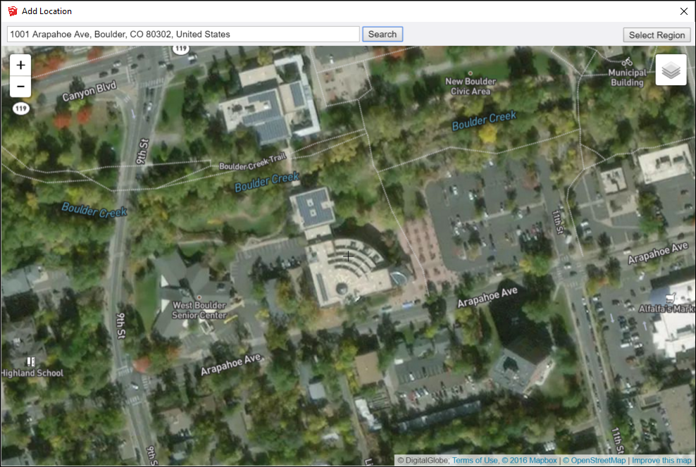
(Optional) To see all the terrain that you want to import, use the zoom controls on the left, or scroll your mouse wheel to zoom in or out.(可选)要查看要导入的所有地形,请使用左侧的缩放控件,或滚动鼠标滚轮进行放大或缩小。Click Select Region in the upper-right. An selection box becomes highlighted in the Add Location window. The highlighted area represents the area of terrain that you'll import into your model.单击右上角的“选择区域”。选择框将在“添加位置”窗口中突出显示。突出显示的区域表示将导入模型的地形区域。Click and drag a corner of the selection box so that the selection highlights only the terrain you need. In the following figure, you see how the aerial view of the library looks after zooming in and adjusting the selection box to highlight only the library building.单击并拖动选择框的一角,以便选择仅突出显示所需的地形。在下图中,您可以看到放大并调整选择框以仅突出显示库建筑后,库的鸟瞰图是什么样子的。Tip:The edges and faces in a terrain add up pretty quickly. The more edges and faces your model has, the more processing power SketchUp needs to render your model on-screen. When you select only the terrain you need, you don't have unnecessary edges and faces bogging down your model.地形中的边和面加起来很快。模型的边和面越多,SketchUp在屏幕上渲染模型所需的处理能力就越强。当你只选择你需要的地形时,你就不会有不必要的边和面阻碍你的模型。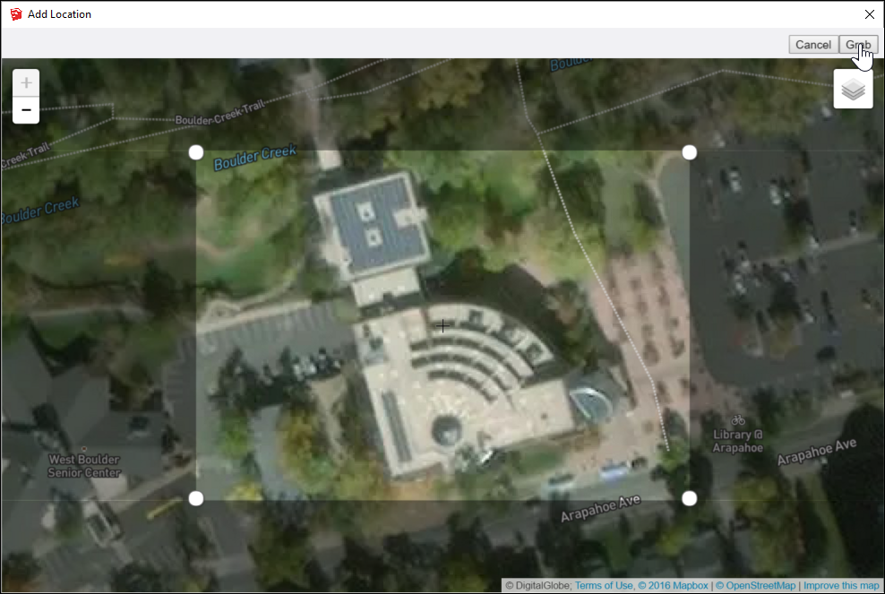
Click the Grab button in the upper right. By default, a 2D image of the selected area appears in your model, as shown in the following figure.单击右上角的“抓取”按钮。默认情况下,所选区域的二维图像将显示在模型中,如下图所示。However, you can toggle between 2D and 3D and change the view to show or hide the Snapshot. Toggling Terrain Visibility explains all your options.但是,您可以在二维和三维之间切换,并更改视图以显示或隐藏快照。切换地形可见性解释了您的所有选项。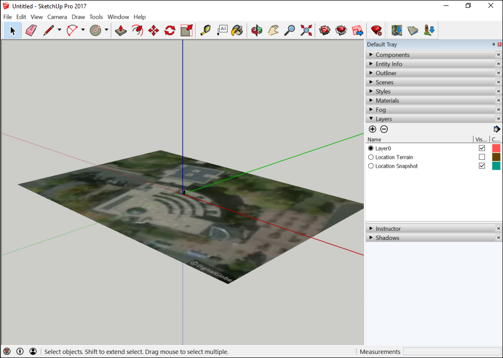
.kmz, this small rotation improves the accuracy of tracing the image as the file is converted from Cartesian coordinates to UTM or Mercator.After you can see your geometry, you can edit it or place your model on it. 看到几何图形后,可以对其进行编辑或将模型放置在其上。Modeling Terrain for Google Earth offers tips specific to geolocated models, if you want to view your model in Google Earth.如果你想在谷歌地球上查看你的模型,谷歌地球建模地形提供了特定于地理定位模型的提示。